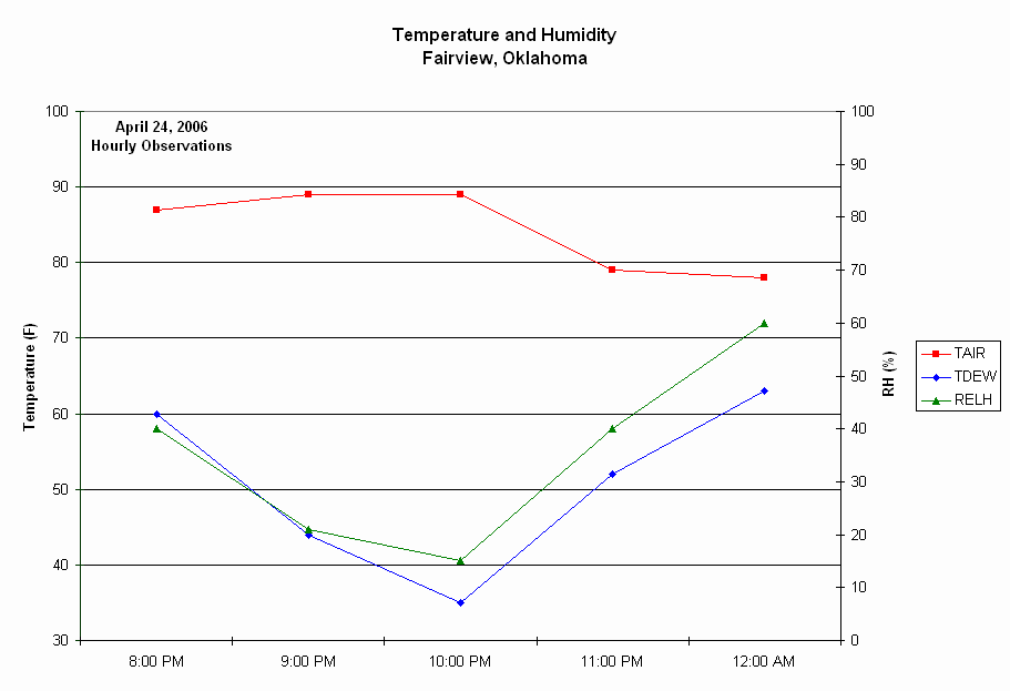
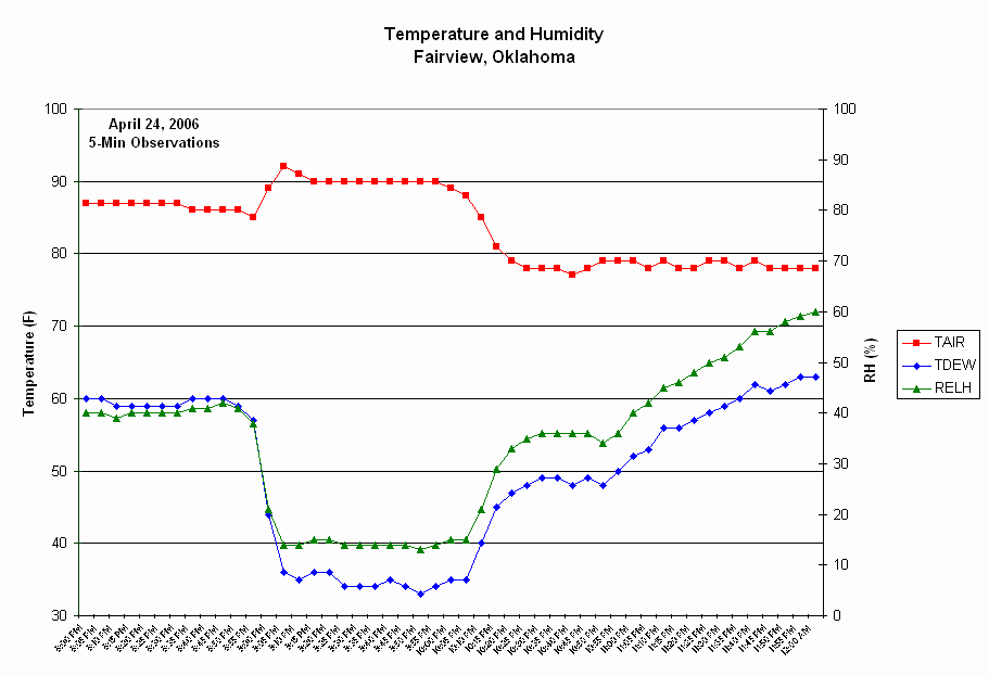
Group 1: TAIR, TDEW, and RH
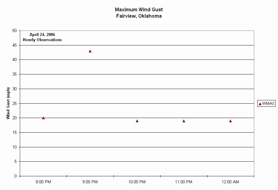
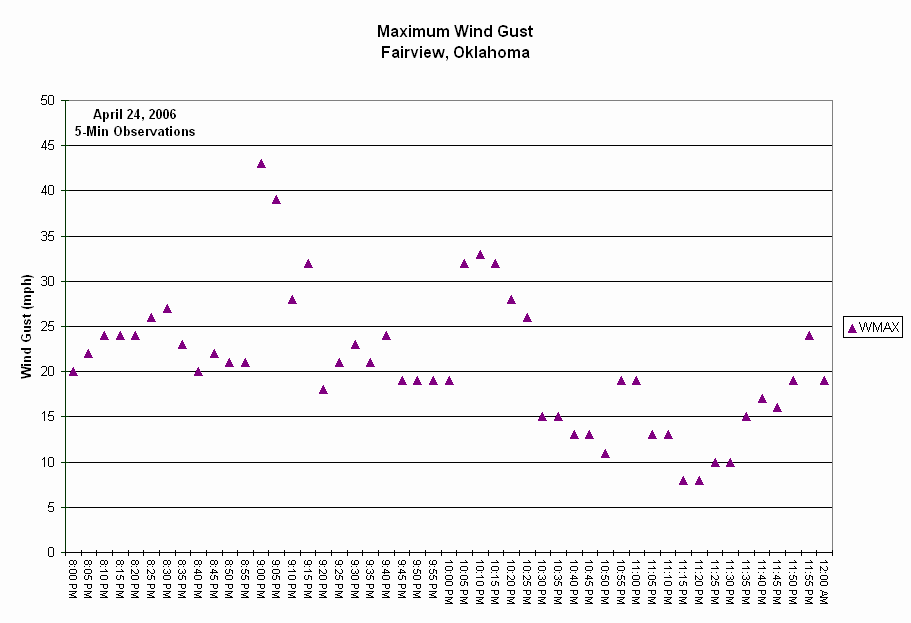
Group 1: WMAX
Assessment / Application Exercises
Plot the following sets of data ("Group 1", "Group 2", and "Group 3") on separate graphs. Plot temperature and dewpoint on the same graph. You may plot RH separately or on a right axis of the temperature graph. Plot the wind gust (WMAX) on a separate graph. You don't have to connect your plotted symbols for the wind gust graphs. With your teacher's permission, you may use a computer to plot Group 3. Answer the following questions at the appropriate times:
After Plotting Group 1:
Like these observations, most weather observing stations traditionally have recorded their data once per hour. What time of day were these observations taken (during daylight or nighttime hours?). How do weather conditions normally change during this time of day? Do the observations in Group 1 fit with your expectations of how weather conditions typically behave?
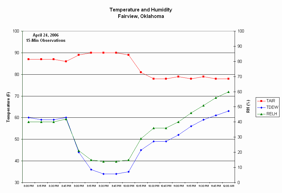
Group 1: TAIR, TDEW, and RH |
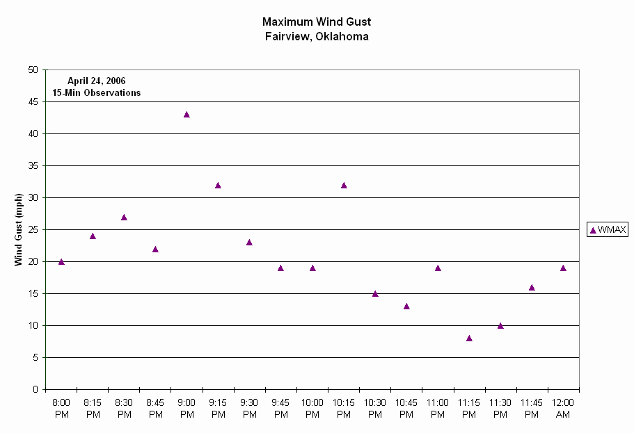
Group 1: WMAX |
|
|
| Click images to obtain larger versions. | |
These observations were taken in the evening, between 8 p.m. and midnight. I expect temperature to decrease during the evening and the observed temperature values eventually exhibit a cooling trend. I expect the wind speeds generally to decrease during the evening. The 9:00 p.m. wind gust was over 40 mph -- it seems higher that the winds before and after. during the night. Perhaps, the 10:00 p.m. humidity observations (RH and TDEW) seem a bit out of place, but there is probably not enough information to know how they "normally" behave. They do increase after 10:00 p.m.
After Plotting Group 2:
Describe the weather conditions observed at Fairview between 9:00 and 10:30 p.m. and compare with the conditions before and/or after this period. What were the maximum temperature, minimum humidity, and maximum wind speed values, and when did they occur? Compare this graph with your Group 1 graph.
Group 2: TAIR, TDEW, and RH |
Group 2: WMAX |
 |
 |
| Click images to obtain larger versions. | |
The temperature rose to near degrees between 9:00 and 10:00 p.m. At the same time the dew point and relative humidity dropped to 30 degrees and 15%, respectively at 9:30. The temperature rise was about 5 degrees but the humdity drop was much larger. At the same time, this hot and dry air was accompanied by strong wind gusts (over 40 mph). The 9:00 p.m. observation from Group 1 now looks like it may have been the onset of the hot dry winds that occurred at 9:15. The Group 2 graph gives a better picture of the duration of the hot and dry winds.
After Plotting Group 3:
The phenomenon observed at Fairview is known as a heatburst. When thunderstorms weaken, they often eject strong downward gusts of wind, called downdrafts, beneath the thunderstorm. Usually, the downdraft contains moist air which evaporates beneath the thunderstorm and cools the downdraft, much like when moisture from your skin evaporates and makes you feel cooler. Sometimes, for reasons meteorologists don't understand, the downdraft contains dry air. When dry air descends, it compresses and warms rapidly.
Heatbursts were once thought to be rare events. From what you have seen in your plots, describe one reason why meteorologists would have thought they were rare. Also, in your answer, discuss which of these three groups of observations is adequate to observe heatbursts. Why do you think the word "burst" is used to describe this phenomenon?
Heatbursts are usually observed at night. Do you think it is possible for heatbursts to occur during daylight? If so, can you think of something that might prevent their observation during the day?
Group 3: TAIR, TDEW, and RH |
Group 3: WMAX |
 |
 |
| Click images to obtain larger versions. | |
The Group 1 chart, consisting of hourly observations, does not clearly show the onset and duration of the heatburst. The entire event occurred in less than 2 hours. If standard observations were taken only once per hour, then many heatbursts probably would have gone undetected. The 15 minute data clearly depicts the heatburst, and the 5 minute data give more detail. The 5-minute data indicate the temperature actually rose above 90 degrees. Strong winds accompany the "burst" of hot and dry air. The term burst may signify a short duration event with strong winds.
Heatbursts are associated with temperature increases. If they could occur during daylight, they may be masked or obscured by the normal temperature increase (warming) that occurs during daylight hours.